This is a dedication to my smart GIS readers, I decided to do something simple and easy to setup, and intuitive to use and make your life much easier for free.
Arc2Google Official Page
I called it Arc2Google. This tool is not sponsored by or affiliated with Arc2Earth
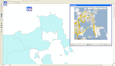
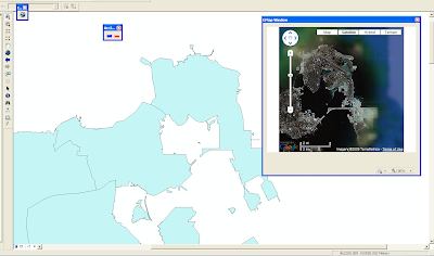
This tool combines ArcMap with Google Maps And Google Earth.
When you activate the tool it open a dockable window inside ArcMap and show you the current Extent on the Map in Google Maps or Earth, it get refreshed whenever you change the view in GIS too.
Watch a Video demonstration of the tool
Or Let the pictures speak.
Click Here to Download The Tool (9.x)
Click Here to Download The Tool (9.x/10)
See the previous tool Integrate ArcMap with Google Earth (VBA)
Please report any bugs found here or email it to me. Any suggestions too. I'll reply immediately
Enjoy
Arc2Google Official Page
I called it Arc2Google. This tool is not sponsored by or affiliated with Arc2Earth
This tool combines ArcMap with Google Maps And Google Earth.
When you activate the tool it open a dockable window inside ArcMap and show you the current Extent on the Map in Google Maps or Earth, it get refreshed whenever you change the view in GIS too.
Watch a Video demonstration of the tool
Or Let the pictures speak.


Click Here to Download The Tool (9.x)
Click Here to Download The Tool (9.x/10)
See the previous tool Integrate ArcMap with Google Earth (VBA)
Please report any bugs found here or email it to me. Any suggestions too. I'll reply immediately
Enjoy
good afternoon bro,
ReplyDeleteis it for astronomy too or just for earth map??
@Manna
ReplyDeleteGood afternoon sis,
No this software is only for ESRI ArcGIS vs Google Earth and Google Maps..
you have specific application in mind?
actully, i search for a good astronomy application, better then google earth
ReplyDelete@Manna
ReplyDeleteWhat's the flaws and problem in Google Earth?
it have google sky
and now few days ago google released Google Moon..
and its free
Have you true the free ArcGIS Explorer with free globes for mars and the moon? Check out http://www.esri.com/arcexplorer You can also develop custom tasks using the free SDK.
ReplyDelete@Marten
ReplyDeleteThat's great didn't know about it,
We should take a look at it..
We could do some mashups stuff with it
Thanks alot for your comment
yes brother, i saw this application
ReplyDeletehowever, i found another software
it is " starry night" its very useful and easy to use :D
thanx again
@Manna
ReplyDeleteIt would be great to provide us with a link to Starry night application
thanks
Great tool, thanks for sharing. Is there any way to manipulate the tool to launch a larger GMap window? I'm working with dual monitors and it would great to be able to maximize Google Earth/Map on one screen with ArcMap on the other. Thanks!
ReplyDeleteGlad it helped Michael,
ReplyDeleteSure! I will work on this fix very soon :)
Thanks for your comment
The tool looks very interesting to me. Please let me ask, will it work with ArcScene? I would like to let a half-transparent raster have its "own topography" when visualised in GoogleEarth.
ReplyDeleteI have wired the tool to work only with ArcMap
ReplyDeletebut yes, I can alter it to work on ArcScene,
In fact I'm working on Arc2Google 2.0 which will add Google Maps as a geo-referenced raster Layer to ArcMap.
This will save so much work.
Sounds great
ReplyDeleteThis comment has been removed by the author.
ReplyDeleteIt looks great in demo video. But it seems like that the google map/earth just focus on the south pole, no whether how I zoom/pan the features in arcmap or changes the coordinate system of the data frame. I'm working under ArcMap 9.3 with a german WinXP.
ReplyDeleteThanks for your comments Rinevle
ReplyDeleteI really love these sort of comment to enhance the tool
Arc2Google is based on approximation, so the more users use the Tool and feedback I get the more accurate I can make it..
can you send me some snapshots of the discrepancy?
That's great. Then where can I find the snapshots? Are they some temporary files ?
ReplyDeleteI don't save the pics in temporary place, but hey, thats a great idea! and it can be done too..
ReplyDeleteI could install an autoheal engine in Arc2Google to automatically adjust the pic based on the history
Thanks for the inspiration
for now just take a snapshot with the print screen and send them to my email
What a handy tool! Do you know if there's a way to display the 3D buildings in the Google Earth window?
ReplyDeleteThanks for sharing your work on this, Hussein!
Rush,
ReplyDeleteglad it helps! :)
Sure I can display buildings, I'll fix it, and you'll get the update automatically..
thanks for the suggestion
Fixed
ReplyDeleteThanks for adding buildings! I'm working on a project where I need to differentiate between surface parking lots and multistory parking garages, and having the 3D buildings makes that much easier.
ReplyDeleteAlways Glad I can help
ReplyDeleteBest of luck in your project :)
Hi Husseyin,
ReplyDeleteI tried Arc2Google with ArcgIS-9.3.1 but it didn't work as saying "unknown projection" even the data (ESRI Sample Data of the world) has projection. What dou you suggest?
Regards,
Hayati TASTAN
Ankara, Turkey
Hi Haytstan,
ReplyDeleteI didn't test it on 9.3.1 but some folks did and they say its working
I had similar problem with some guys from germany
Can you send me a sample shape file of your data? so i can test it
Thanks for this great tool!
ReplyDeleteDoes anybody test Arc2Google on ArcGIS 9.1?
Hi Francis,
ReplyDeleteit should work on 9.1 if you have framework 2.0
but I didn't test it..
You have the code you can recompile it
hi, great tool, saves flipping between windows, would there be an easy way of adding in user created maps from googlemaps, so as to offer more detail for urban areas,
ReplyDeleteThanks Edward,
ReplyDeleteUser created maps? if that is available on Google Maps sure I can add it..
Hi, great tool Akhii husein, but i have problem when click on register.bat or registerADF.bat, i use arcGis 9.2 and .Net Framework 2.0.5
ReplyDeleteCan you help me
thanks
Luthfi
hi lutfi,
ReplyDeletecan u tell me whats the error you are getting.
hi, grat tool, but i have problem when click on registre.bat:
ReplyDeleteRegAsm: error RA0000: failed to load 'c:\ ...\arc2Google.dll` because it is not a valid .net assembly
can you help my
Fernando
hi fernando,
ReplyDeletewhats your .NET Framework?
What is the version of ArcGIS?
please download the latest framework from here.
http://www.microsoft.com/downloads/details.aspx?FamilyId=0856eacb-4362-4b0d-8edd-aab15c5e04f5&displaylang=fr
my windows is Microsoft Vista x64
ReplyDeletemy .net framework is 3.5 sp1
the vesion of arcgis 9.3
I download de .net framework yet
Try running the Register.bat under the 2008 folder
ReplyDeletesend me an email on hus.mhd@gmail.com to continue to support
Download the SDK for 2.0 to fix the problem...
ReplyDeletehttp://www.microsoft.com/downloads/details.aspx?familyid=fe6f2099-b7b4-4f47-a244-c96d69c35dec&displaylang=en
attempts to reinstall the framework
ReplyDeletegood, download the SDK for 2.0 to fix the problem the file is large,
ReplyDeleteI notice when finished will try another look thanks
salam houssein,
ReplyDeletecan u help me in 2 pb:
1) is there a tool to convert from international coordinate system (565656,762822) to a gps coordinate.
2) i run th tool but an error(user-defined type not defined); how to fix this error.
thank you
Salam
ReplyDeleteIn ArcObjects, using the CreateGeographicCoordinateSystem(esriSRGeoCSType.esriSRGeoCS_WGS1984)
use this function
Sub PointToLatLon(ByVal pMxDocument As IMxDocument, ByVal pPoint As IPoint, ByRef dLatitude As Double, ByRef dLongitude As Double)
On Error GoTo EH
' variables for dealing with projections and units
Dim pSpRefOutput As ISpatialReference
Dim pSpRefInput As ISpatialReference
' set the spatial reference of output KML data
Dim pSpRFc As SpatialReferenceEnvironment
Dim pGCS As IGeographicCoordinateSystem
pSpRFc = New SpatialReferenceEnvironment
pGCS = pSpRFc.CreateGeographicCoordinateSystem(esriSRGeoCSType.esriSRGeoCS_WGS1984) 'esriSRGeoCS_WGS1984
pSpRefOutput = pGCS
pSpRefOutput.SetFalseOriginAndUnits(-180, -90, 1000000)
Dim pGeometry2 As IGeometry2
pGeometry2 = pPoint
pSpRefInput = pMxDocument.FocusMap.SpatialReference
' project feature into latitude/longtitude if necessary
pGeometry2.SpatialReference = pSpRefInput
pGeometry2.Project(pSpRefOutput)
Dim pNewPoint As IPoint
pNewPoint = pGeometry2
dLatitude = pNewPoint.X
dLongitude = pNewPoint.Y
EH:
End Sub
hope this helps
Dear Hussein, congrats for the tool! It can be very helpful. However when I open a shapefile and then try to project it on GoogleEarth it goes somewhere far outside the map. What I am doing wrong.
ReplyDeleteThank you!
Adelais
Hi Rika,
ReplyDeletecan u send me a sample of this shape file on my email to study it?
Hi,
ReplyDeletegreat that ur doing for the sake of ease in life...
well is it compatible with ArcGIS desktop 10?
We have AGD 9.3 and we are looking for 10th version
regards,
Akshay
goa,India
hi
ReplyDeletethis is the 10 version
http://hnaser.blogspot.com/2011/01/arc2google-for-arcgis-10.html
hi hussein,
ReplyDeletecould u help me
when i try to register.bat
then error coming
Microsoft (R) .NET Framework Assembly Registration Utility 2.0.50727.3053
Copyright (C) Microsoft Corporation 1998-2004. All rights reserved.
RegAsm : warning RA0000 : Registering an unsigned assembly with /codebase can ca
use your assembly to interfere with other applications that may be installed on
the same computer. The /codebase switch is intended to be used only with signed
assemblies. Please give your assembly a strong name and re-register it.
RegAsm : error RA0000 : Could not load file or assembly 'ESRI.ArcGIS.SystemUI, V
ersion=9.2.3.1380, Culture=neutral, PublicKeyToken=8fc3cc631e44ad86' or one of i
ts dependencies. The system cannot find the file specified.
Press any key to continue . . .
help me plz
Hi,
ReplyDeleteInsert ArcGIS installation CD and then go to customize make sure the .NET Support is installed ..
não está dando certo. quando adiciono uma shape no arcmap, no googleearth é mostrado outra área.
ReplyDeleteobrigado
Igor
HI Nasir..Really a a good tool but after installing I m not getting the Google in Extensions.....
ReplyDeletehi majid
ReplyDeletetry this..
http://hnaser.blogspot.com/2011/09/arc2google-for-arcgis-101-compatible.html
Hi Hussein
ReplyDeleteReally good working.But I have got a problem with this extension.I cant find a tool in arcmap customize skip.
Thanks for the reply...I m using ArcGIS 9.3....I downloaded "arcgis-101-compatible" but still not getting it in Extensions it shows registration failed...
ReplyDeleteyou should download the 9x installation, not the 10.
ReplyDeletetry again and let me know
----
Go to arcmap, customize,
add from file then select Arc2Google.tlb from the installation folder c:\program file\arc2google
yes, but i don't see any thing. Can U help me
Deletesr,but i can't find it in toolbar.
ReplyDeleteCan U help me ?
Wonderfull.......i like it..
ReplyDeletethank u hussein.........Allah bless your masterpiece
Dear Hussain
ReplyDeleteI have installed Arc2google and toolbar appears in menu in arcmap as well but when i click to see the area in the Google earth using this tool then nothing happens. I am using win vista.
Please try to redownload the tool, from here
Deletehttp://geshout.com/Arc2Google/index.html
Hi there. I'm having a similar experience to Farooq's. Having installed the plugin on Arc 10.0 SP2 under Win7Pro, the Google Earth nav window only appeared the first time I tried clicking the "E" button in the toolbar. The display said that I needed to restart my "browser" to get the plugin to work. Upon restarting Arc, the display does not appear when a toolbar button is clicked.
ReplyDeleteThanks for putting this thing together!
Just a little follow-up to my case. Seems it attempts to open an IE browser that thumbnail/previews correctly when I mouse over it's tab on the start bar (Aero interface on), but appears blank white with a few black elements on the perimeter when it is made the active window. It also does not respond to any user input.
DeleteI have updated Arc2Google and removed the dockable window...
Deleteplease try again,
http://geshout.com/Arc2Google/index.html