Yes, you might find thousand of sites that explains the GIS, but most of them are way to technical to digest.
This blog post is for people who just want to grasp a quick idea about GIS so you can engage into conversations easily.
So I'm going to make it really simple, straight to the point and yes, concrete.
What is GIS?
Now GIS stands for Geographic Information System, but really I love to treat it more like lens
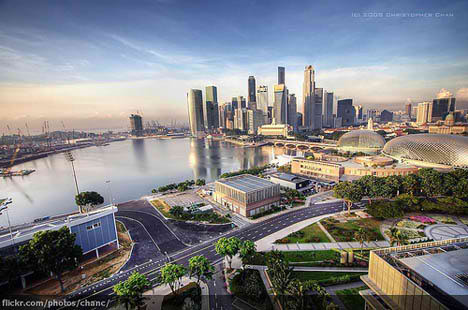
Lets take a bird-eye view at your town. You see buildings, streets, people walking. There are things you don't see like underground electricity cables, water networks. There are things you might not care about like Post offices or supermarkets or small buildings or trees.

What GIS does is separate all these elements into "Layers" that you can turn off and on so you can have a clear bird-eye view of what you "care" to see.
Questions that pop-up to your head now can be answered easily, like, how many buildings surrounds this lake? or What is the largest building in this area. Such questions involveing a combination of these layers together form the IS part of GIS. The Information System.
GIS Examples
A Geographic Information System that represent the Electric Network in Bahrain
A Geographic Information System that shows the Sewerage network in London
A Geographic Information System that shows the high signals in my Left Brain.
A Geographic Information System that shows Nuclear Plants in the World.
You may add to the list.
Answer Interesting Questions
You may also combine GIS systems together to answer questions like, how many High-Voltage Cables passes near the Nuclear Plants in UK?
GIS Applications
Here are some GIS Applications
ESRI ArcGIS
Google Earth
This blog post is for people who just want to grasp a quick idea about GIS so you can engage into conversations easily.
So I'm going to make it really simple, straight to the point and yes, concrete.
What is GIS?
Now GIS stands for Geographic Information System, but really I love to treat it more like lens
Lets take a bird-eye view at your town. You see buildings, streets, people walking. There are things you don't see like underground electricity cables, water networks. There are things you might not care about like Post offices or supermarkets or small buildings or trees.
Questions that pop-up to your head now can be answered easily, like, how many buildings surrounds this lake? or What is the largest building in this area. Such questions involveing a combination of these layers together form the IS part of GIS. The Information System.
GIS Examples
A Geographic Information System that represent the Electric Network in Bahrain
A Geographic Information System that shows the Sewerage network in London
A Geographic Information System that shows the high signals in my Left Brain.
A Geographic Information System that shows Nuclear Plants in the World.
You may add to the list.
Answer Interesting Questions
You may also combine GIS systems together to answer questions like, how many High-Voltage Cables passes near the Nuclear Plants in UK?
GIS Applications
Here are some GIS Applications
ESRI ArcGIS
Google Earth
Really you have described uniquely the definition of GIS and beautiful represented your thought in this blog post. Many thanks for the great piece of work...
ReplyDelete